 Clean Water OUR FUTURE


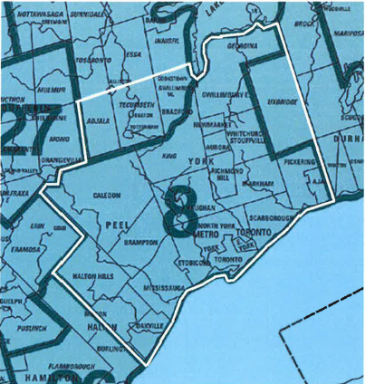
Geographic area map
SCHEDULE "A"
Boundary Description of Board Area 8
Southeast Corner
Beginning at the intersection of Lake Ontario and the southerly extension of Lakeridge Road (Regional Road 23), North along Lakeridge Road to the Uxbridge-Pickering Townline.
West along the Uxbridge-Pickering Townline for approximately 1000m, to the place at which the traveled road ends, then continuing along the unopened Original Road Allowance (ORA) till Westney Road at which point the traveled road re-appears. Continuing along the Uxbridge-Pickering Townline to its intersection with the Uxbridge-Markham Townline (Regional Road 30).
North on Regional Road 30 to a point approximately 600m south of Highway 47 at which point the traveled road deviates to the east of the ORA, there continuing along the untraveled ORA returning to the traveled road near Highway 47. Continuing north on Regional Road 30 to Lot 20 Concession 1 Township of Uxbridge at which place the road deviates to the east of the ORA, there continuing along the untraveled ORA, returning to the traveled road near the intersection with Wagg Road. Continuing north on Regional Road 30 (Road Allowance between the Townships of Scott and East Gwillimbury) and its continuation as Township of Uxbridge Con 1 to its intersection with Regional Road 32 (Ravenshoe Road, Road Allowance between the Townships of Scott and Georgina).
East on Regional Road 32 to its intersection with Regional Road 23 (Lakeridge Road, Road Allowance between Townships of Georgina and Brock).
North on Regional Road 23 (Lakeridge Road) and the production thereof namely Thorah Park Boulevard to the south shore of Lake Simcoe.
Northeast Corner Lake Simcoe
Then, following the shore of Lake Simcoe in a generally westerly and southerly direction to its intersection with the centreline of the Holland River.
Southerly and westerly along the centreline of the Holland River, the centreline of the West Branch of the Holland River (not to be confused with the west or east canals in the Holland Marsh) and the centreline of the Schomberg River to its intersection with Leonard Road (Road Allowance between the Townships of King and Tecumseth).
South along Leonard Road to Highway 9 (Road Allowance between the Townships of King and Tecumseth).
West along Highway 9 to a point 800m east of Airport Road (eastern edge of the Village of Mono Mills where Highway 9 deviates south). There continuing along the unopened road allowance, crossing Airport Road approximately 200m north of Highway 9, until Highway 9 rejoins the road allowance approximately 400m west of Airport Road.
Orangeville
West on Highway 9, then along Buena Vista Road to its intersection with Highway 10.
North along Highway 10 to the intersection with Broadway.
West along Broadway to Townline Road.
South and west along Townline Road to the intersection with Porterfield Road, there continuing along the unopened ORA, then continuing on Townline Road westerly to the intersection with Winston Churchill Boulevard (ORA between the Townships of Erin and Caledon).
Northwest Corner of Peel
South on Winston Churchill Boulevard (Peel Regional Road 19) to Bush Street (Peel Regional Road 11, Wellington County Road 42). Continuing along the untraveled ORA across Bush Street until Winston Churchill Boulevard rejoins the ORA.
South on Winston Churchill Boulevard to Balinafad Road (Wellington County Road 42, Halton-Erin Townline, Side Road 32).
Southwest along Balinafad Road to the Eramosa-Erin Townline (Road Allowance between the Towns of Milton and Halton Hills, ORA between the Townships of Eramosa and Erin).
South on the Eramosa-Erin Townline, crossing Highway 7 and continuing on Crewson's Road a distance of approximately 1000m, to the place where the traveled road turns east. At which point continue on the unopened road allowance and then the traveled road to Sideroad 15. Then continuing south along the unopened ORA (ignoring a parallel deviation road located to the west of the ORA) for a distance of 600m until the traveled road rejoins the ORA. Continue south along the traveled road until it ends then continuing along the unopened ORA until the traveled road reappears as Tremaine Road (ORA between the Townships of Nelson and Trafalgar).
South on Tremaine Road, and on the unopened road allowance at a deviation to the east located 2000m north of Lower Baseline Road, returning to and along the traveled Tremaine Road to its end at Dundas Street.
South on the unopened ORA between the Towns of Burlington and Oakville, crossing Bronte Creek, until returning to a traveled road named Burloak Drive in the ORA some 200m north of Upper Middle Road.
South on Burloak Drive and the production thereof to the north shore of Lake Ontario.
Lake Ontario
East along the north shore of Lake Ontario to the point of beginning.
Including in Board Area 8 the following lands outside of the perimeter directions description above.
Fox, Snake and Georgina Islands in Lake Simcoe,
All of the lands known as the Toronto Islands in Lake Ontario.
All manmade landfill or structures extending from the shores of Lake Simcoe, Lake Ontario, the Holland River, the west branch of the Holland River and the Schomberg River.
The waters and bed of Lake Simcoe extending to the limit of the municipal jurisdictions, as they extend into the lake, of East Gwillimbury and Georgina.
The waters and bed of Lake Ontario extending to the boundary of the Province of Ontario to the limit of the municipal jurisdictions, as they extend into the lake, of Oakville on the west and Ajax on the east.
GREATER TORONTO SEWER & WATERMAIN CONTRACTORS ASSOCIATION
5045 Orbitor Drive, Unit 12, Suite 300 Mississauga, ON L4W 4Y4